Thursday 5 July 2012

The return trip

There wasn't anything eventful on the return trip to Sydney. The scariest thing we did was a night drive from Coober Pedy to Broken Hill. All you see is black and whatever the lights manage to illuminate. I had a close call almost running over what appears to be a dingo.

I did manage to take a wonderful shot of the Breakaways. The previous shot was in the mid-morning sun. This one was right on sunset! It truly is amazing how the light changes a whole landscape.

The Breakaways at sunset
Compare the shot to the mid-morning take

Monday 2 July 2012

Our last sunset at Uluru (Day 4)

Our exceptional day ended with a sunset at Uluru. As we excited the park, all three of us reflected back on our amazing journey. This video is the last time lapse I did of the rock. Enjoy!


Thursday 28 June 2012

Uluru Base Walk (Day 4)

This was our final day at Uluru. All of us were tired from all the walking, fatter because of all the eating and closer because of all the road trip conversations. Our last day was spent on the base walk. This walk is about approximately 10.4 km and is a loop circuit around the base of Uluru. You get right up and personal with the rock and it sure does make you feel small, tiny and insignificant.

Around the base there are a few areas that are sacred to the first Australians and you are not allowed to take photos. The walk has two areas where the Mala people did rock paintings. I was glad that we did the walk, it was a good end to an excellent trip.


Map of the base walk with locations I photographed below
Photo location 1, Mala rock painting

Photo location 3, rock art. The swirls represent water

Photo location 2, Mutitjulu waterhole. The most reliable source of water at Uluru
Photo location 3, rock art

Sunday 24 June 2012

Sunrise at Uluru (Day 4)

You may have noticed that I have taken a fascination over time lapse photography. The previous one was my first attempt at this form of photography. This was the second attempt which was of Uluru at reverse angle.

This was a reverse sunset, which is in a location the tour buses avoid at this time. You see the change in sky colour followed by the golden sun on the clouds and then the grass!

Enjoy!


Friday 22 June 2012

We are small (Day 3)

Uluru and Kata Tjuta are the only landmarks on an otherwise flat featureless desert. To appreciated this we hired a helicopter for a aerial tour of the national park. I hope the readers enjoy these photos, which show just how small we are and the vastness of nature.

Me with three birds
The red center is a semi-arid environment

Uluru in its semi-arid environment
In this photo is the Lesseter Highway which is the main road into Uluru. On the left is smoke from a back burning operation and on the right is Ayers Rock Resort
Uluru and Kata Tjuta (the Olgas)
Ripples of life

Some humans are stupid (Day 3)

I was raised to respect other cultures. Since the hand over of the Uluru-Kata Tjuta National Park to the Anangu people the first Australians hold the rock as sacred. They will not forbid you from climbing Uluru, but expect you to show some respect by not climbing. At the base of the walk there is a sign in 6 different languages expressing the wishes of the traditional owners of the land.

We witnessed the amount of disrespect some people had for these wishes ourselves. Tour bus after tour bus unloaded more people. These people are so excited to climb the rock, they run to the base and start the climb.

We don't climb so why the bloody hell do you climb!
It was amusing to watch people climb Uluru. No less than 35 people have died on this endeavour. If you just round the corner, there are 8 plaques which commemorate the passing of individuals claimed by the very difficult and dangerous climb. You see people start and chicken off. Ones that just stop on the incline petrified with fear. Others bumming it down or the ones that grab tightly to the chain. I even saw a stupid individual jog down to help his partner crying on the incline! One slip and many people will die or get hurt.

SERIOUSLY PEOPLE, STOP THIS MADNESS!!!
You read about how people think it is okay to climb, because they paid park entry fees. How just because Uluru is sacred to the first Australians it isn't relevant to them so they climb. Well how about this climbers! What about the environmental reasons to stop you damaging Uluru!

The site is a source that sustains life; the climbers damage this ecosystem and will spoil it for countless generations of humans and destroy the wildlife Uluru supports. If you want to know more see this link  or ask the rangers about the contaminated waterholes at the base of Uluru.

You can see the white path climbers have eroded on the rock

Mala Walk (Day 3)

People pay the tour operators hundreds of dollars for a bus ride and tour around Uluru. At times the information given is inaccurate. Ask yourself this, do the tour operators know and work with the first Australians? Do they respect the culture and significance of the site? I bet, most of your answers would be 'NO'.

You may not know this, but the Uluru-Kata Tjuta National Parks offer a free guided tour at the base of Uluru. This tour is called the 'Mala Walk' and is highly educational. The ranger takes us through the history and culture of the Anangu first Australians. They work with the Anangu community to ensure that Uluru is preserved for all.

This tour is a must  and I highly recommend people to take the walk, learn and embrace the experience. The tour ended at the Kantju Gorge. You really get to see Uluru up close and it was a fabulous experience. 

Uluru natural colour is a light grey with an iron composition. The red you see is the result of iron oxidation (otherwise known as rust). You can really see the colours in this shot. The oxidised section of the rock flake off and can be a hazard to tourist as they drop from the top
Us at Kantju Gorge, which is one of the many waterholes at the base of Uluru
Something you may not know is that Uluru is a major source of water for the area. The rock stores and releases water and basically supports the life around it. You can see how the vegetation changes for each of the waterholes that make up Uluru.That is why this place is sacred to the first Australians.

Sky, rock, trees

Thursday 21 June 2012

Tali Wiru (Day 2)

It is time to tell the readers a secret. People rave on and on about the 'Sounds of Silence' dinner at Ayers Rock Resort. This dining experience takes you to a location where you enjoy a buffet dinner. You are seated in groups with people from other nationalities. It is all good if you like buffet dinners and lots of people, but for a more refined a la carte and personal experience the Tali Wiru dinner is for the foodies.

For $329 per person you are taken to a small dune and seated on a personal table. We had 8 other couples with us, we were the only group of 3. The menu is a la carte with matching wines. The evening starts with a bus ride to the dune. We had to walk up to the dune where canapes and champagne await.

The canapes were:
  • Gorgonzola Cheese Tartlet (very yum)
  • Sweet Potato and Lemongrass Soup
  • Western Australian Tuna Tartare with Finger Lime Caviar (mmmMMMMM)
  • BBQ'ed Hervey Bay Scallops (yum yum)
Entertainment was by a local didgeridoo player.

After canapes we were taken to our table where we enjoyed a candlelight dinner. There was no electricity on the dune. The chefs, waiting staff and us all relied on either a gas cooker, torches and a single candle on the table for the night. Heat was provided by several radiantly placed wood fire heaters. 

We had entree and mains and saw the stars! My selection was the Butter Poached King Prawns, Macadamia and Lemon Myrtle Crusted Barramundi Fillet (Gaaarrrgh).

Waiter serving another table under touch light. This is a long exposure so the star trails were captured

Now before anyone asks, yes there were insects but it wasn't as bad as you may think. They were more concerned about the light than our dinner. Occasionally one flew into your wine glass but the staff always gave you a new glass and a top up.

TIP: Drink fast and hope for a bug, that way you get more wine.

See how clear the stars are at night!
Dessert was a Dark Chocolate and Chilli Mousse with my favourite dessert wine De Bortoli 'Noble One'.

The night rounded off with all of us around a fire with a first Australian sharing his experiences with us.

The night ended with a story around a camp fire with some fine XO
Needless to say all of us stumbled cheerily to the bus as our experience ended!

Wednesday 20 June 2012

Valley of the Winds (Day2)

Kata Tjuta or otherwise known as the Olgas has two walks that you can take. The one we opted for was the valley of the winds. The grade is difficult and you do require good footwear and some common sense when walking the track.

The track is A-M-A-Z-I-N-G! It starts of as an easy 2 km walk from the car park to the first lookout. From there, it becomes progressively more difficult. If you go hard, you will be rewarded with the most spectacular landscapes! Below is a map coded to the scenery we saw during the walk. In total the whole course was about 14 kms from the car park and its return leg.

A map of the walk, the numbers correspond to the photos below

Photo 1, with my triforce beanie I entered the valley of the winds


It was a 2 km walk from the car park to the first lookout point at the valley of the winds. If weather permits the national parks will allow you to walk the loop. This rest stop gave an excellent view of a valley. You felt so small next to the mountains and I was certainly humbled.

Photo 2, the view from the first lookout
Given that the temperature was only 23 degree the harder walk was opened. We met a crazy Aussie on crutches trying to hop the next section. Needless to say, he gave up as the terrain became steeper and less 'hop' friendly. At the start of the harder route's loop we met some Argentinians that advised us that it got really difficult beyond the bend and they turned back. We were young and decided to man up and pressed on.

Photo 3, the start of the difficult loop. We showed those Argentinians by pressing on

Guachita won't let me post the photos of her climbing up a steep incline but at the end of this we were all tired and though that we 'bit off more than we can chew'. But there were no options, press on was the only option.

Photo 4, looking back at where we have been. We climbed up that valley to reach this high point for a shot
The next part was a cool walk in the valley with the mountains flanking either side of us. The next photo showed just how small all of us were.

Photo 5, the valley had many levels but still the mountains flanked us and showed all concerned how little we all are
They valley was flat and then it climbed up and up. With all our strength we navigated up the slopes. At this point we all were tired and exhausted. What awaited us at the end of the climb was breath taking, awe inspiring, gob smacking and hit you right in the face!!!

Photo 6, there was complete silence at the lookout
The rest of the hike was easy. Down the valley on Photo 6 was a bit of a hazard with small rocks that can aid in giving you an express ride down. Other than that, it was generally easy. The landscape still surprised us at the end of the loop.

Photo 7, speaks for itself
Photo 8, shows the landscape of the desert as seen on the track
This walk was SOOOOOOO worth the pain. I would recommend it to everyone. The sound of silence in the valley was unforgettable.

Tuesday 19 June 2012

Uluru at Sunrise (Day 2)

There is a lot to be said about Uluru. For a start the land is owned by the Anangu people and was only recently handed back to them in 1985! The first Australians have lived in this country for over 30,000 years and have built up a culture that should be preserved as our nation advances.

We started the day early to see Uluru during sun rise. Video is a time lapse over 40 minutes at Uluru. A video speaks a thousand words, so please enjoy.


Uluru-Kata Tjuta National Park (Day 1)

We made it! It was just 1.5 hours before sunset when we arrived at Uluru. They say that seeing the rock for the first time is a magical experience. I must confess it is indeed true! Out of the flat plains of the red center of Australia there are two landmarks, Uluru and Kata Tjuta (Mount Olgas).

I only had time for a quick snap shot as the sun went down. Unfortunately there were only clouds around the rock, so there wasn't any colour changes in the sky. It was still breath taking.

The Rock!

Monday 18 June 2012

Towards Uluru

About 750 kms from Coober Pedy is our final destination, Uluru. Only a 7-8 hour drive until we see this wonder! We felt excitement as we departed Coober Pedy.

The great thing about road trips is that you can detour slightly while still be on track for time. We had just this opportunity on departure. I wanted to see the Break Aways which was only 32 kms North of  Coober Pedy.The locals advised that we can drive to the Break Aways using our car as it has not rained in the area for some time. If there was rain, we needed a 4WD since the road was made up of dirt.

The trip towards the Break Aways was bumpy and rough. The car shook and vibrated, but after 20 mins we were there. Kidneys and stomach were a touch in a knot and displaced.

It was just after 9:30 am, so we missed the early golden light on the Break Aways. Still will a tripod in hand and some nifty traditional photography techniques I captured the following.

Looking over the edge at the Break Aways
Break Aways from another lookout point
The half way point for this part of the trip was the border between South Australia (SA) and the Northern Territory (NT). There is a major rest stop that highlights the border. Unfortunately, the border point lacked character and someone ran off with each state's emblem!

A sad border crossing. We all prefer the border cafe one!
 
For the first time ever, I was able to take the car up to 130 kmph, which is the speed limit for the Stuart Highway, NT side. Sadly, if we made this trip 6 years earlier, the speed limit was as fast as your car can go! Overtaking was easy at this speed as the road trains can only travel 100 kmph.

On the way to Uluru we saw Mt Conner at a rest stop. The ground was red as red can be, we had indeed entered the red center of Australia.
Mt Conner in the background. Don't mistake it for Uluru

Sunday 17 June 2012

Coober Pedy

We left Broken Hill early for Coober Pedy with a long drive ahead we started early. In fact this section would require approximately 9.5 h of road travel! No time for a lunch stop on this part of the journey.

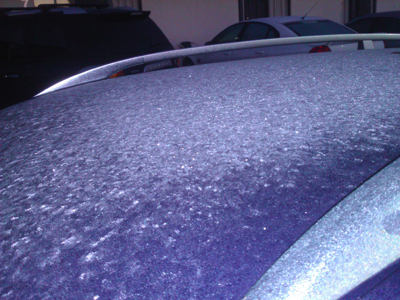
When we hoped into the car, the temperature was 3.0 degrees Celsius. There was ice on the roof of the car. Rugged up we departed.

Ice on the roof as we departed Broken Hill
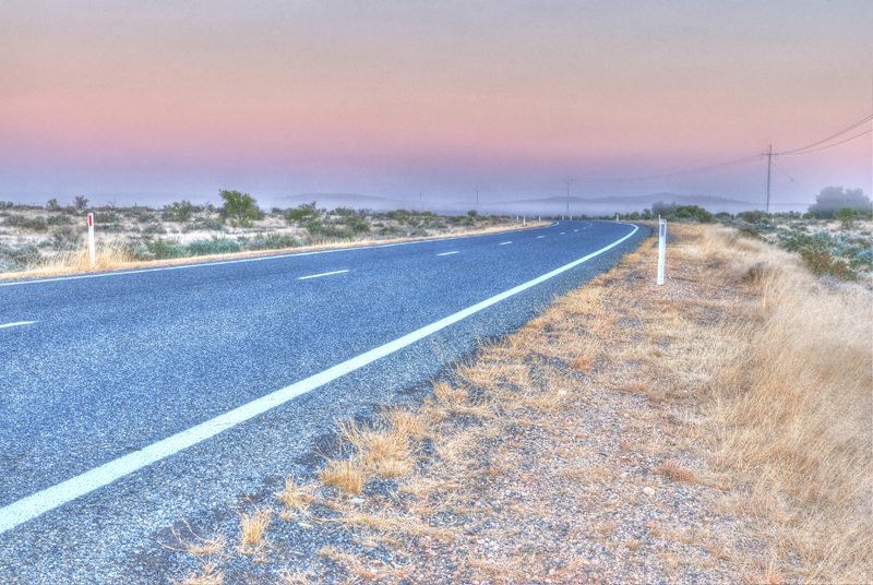
As we drove away from Broken Hill the desert was covered in fog and there was an amazing hue in the sky. I couldn't resist and had to take a shot. The cold was terrible as I took the shot, road trains and cars that passed by and directed horrible penetrating cold burst of air towards you. But it was worth it as you can see.

A foggy desert morning.
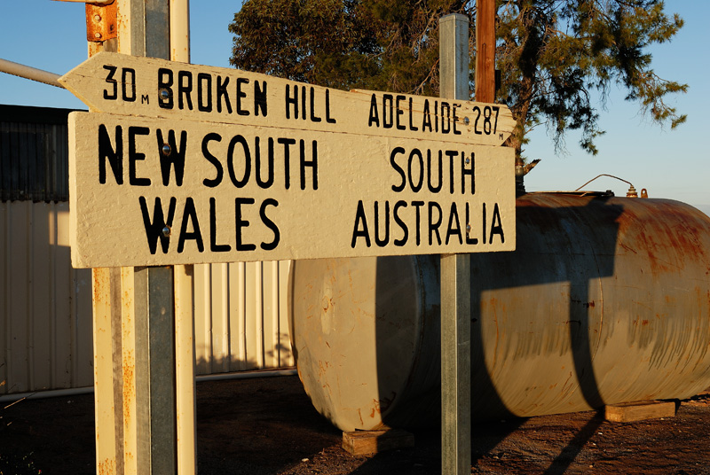
With a border to cross and many kilometers; we drove and ate as we cruised to Coober Pedy. About 1.5 hours away from Broken Hill we reached the border between New South Wales (NSW) and South Australia (SA).

Sign outside the border cafe to mark the border.
The total length for this part of the journey was 970 kms, which is just beyond the range of the diesel Golf Wagen. The car was averaging between 5.7-6.1 L/100 kms (965-902 km  per tank). We could have made it on the one tank but it was not worth the risk as the Stuart Highway only had mobile phone coverage at Coober Pedy and Port Augusta. We refueled at a small place called Glendambo.

Diesel was $1.73 per litre at Glendambo, at the time Sydney prices were averaging about $1.51!
That is right only 30 humans on Glendambo

On the drive along the Stuart Highway there were many lookout points. This one is of a dried up lake with its salt bed exposed


We reached Coober Pedy just before sun down.

In the background are the opal mines. There were piles and piles of dirt around the mining areas
Welcome to Coober Pedy. The mining vehicle marks the entry to Coober Pedy
In Coober Pedy there are about 3000 people. Two thirds of the population live in what's called 'dug outs' which are underground, the rest lived above ground. They build their homes into the hillside like hobbits but without the green luscious fields. Coober Pedy was quite the opposite, it was arid, bare, flat and very dusty. We stayed in the Desert Cave Hotel and had a dug out room.

There was no sound between us and the neighbours. When the lights were off, you saw nothing! The temperature was constant but it smelt like chloride throughout the enclosure. There was an air hole which fanned fresh air into the rooms. Needless to say we had a very good sleep that night.
Some advice if you are claustrophobic, don't stay in a dug out.
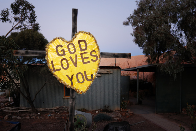
We checked out the catacomb church which was a dug out church the night before departing Coober Pedy. Pretty neat place!

Indeed he does having made it this far
Inside the Catacomb church at Coober Pedy
Next day we start the trip to the rock!

Broken Hill

The vibe in Broken Hill was of excitement! After the sad state of Dubbo, this major town had character, life and a buzz about it that is difficult to describe. Like Cobar, they are proud of their mining heritage. There are statues about it everywhere around the town. The visitors center was built on top of a mining hill and overlooks the town. Very very cool!

We arrived just in time to check out the giant bench and checked out the sunset over the Broken Hill desert.

Feeling like a kid again on the giant bench
Sunset at Broken Hill's sculptures by the desert (the living desert reserve). I couldn't resist and ignored the exhibition to take this shot
Another sunset shot
On reflection, I wished we could have spent more time in the town.

Cobar

Cobar is a small country town in outback New South Wales (NSW). We quickly drove past this area but can immediately tell they took pride in their mining industry. It was evident throughout the town.
The sign entering Cobar
You can tell they are proud of their mining industry when the main lookout is of a mine!

The road down to the lower levels of the mine


Cobar mine
Depth, colour and geometry of a mine